


“Bomb cyclone” brings blizzards to Midwest as storm turns to East Coast. Maps show latest forecast.

A powerful storm system that brought heavy snow, rain and strong winds across parts of the northern United States became a “bomb cyclone” that brought blizzard conditions to parts of the Plains and Great Lakes on Monday, and the system continues to take aim at the East Coast with frigid temperatures and high windsTuesday, forecasters said.
A bomb cyclone is defined as a storm that rapidly intensifies, as measured by a large decrease in its atmospheric pressure over 24 hours, according to the National Oceanic and Atmospheric Administration.
In this case, meteorologists warned that a frigid Arctic front plunging downward into the middle of the country could clash with warm air in the South and potentially cause a range of hazardous conditions, from snowstorms to thunderstorms, along with unusually cold temperatures.
Maps show the winter storm forecast
The winter storm swept across the Great Lakes and moved into the Northeast, bringing blizzard conditions, lake-enhanced snow, high winds and an icy concoction of freezing rain, CBS News meteorologist Nikki Nolan said.
CBS News
Metropolitan areas in the path of the storm include Detroit, Pittsburgh, Philadelphia, Washington, D.C., Buffalo, Syracuse, New York City and Boston.
Along with snow, interior spots in New England should prepare for ice to accumulate, with close to 1 inch possible in certain places, forecasters said. Other areas could receive up to 2 inches of rainfall, while wind gusts could also reach 65 or 75 mph as the storm rolls through.
The storm is also bringing fierce wind conditions to the Northeast. Hurricane-force winds whipped across Buffalo, with gusts up to 79 mph.
CBS News 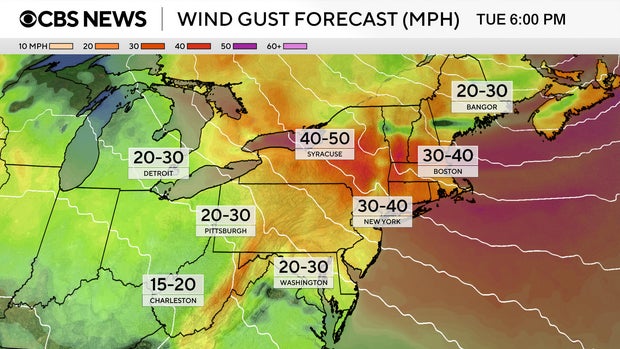
A surge of cold air arriving behind the cold front will allow lake-effect snowfall to pile up. Upwards of a foot of snowfall is expected downwind of Lake Erie and Ontario over the next couple of days as the cold air continues to move over the relatively warmer lakes.
Lake-effect snow warnings are in effect through Thursday morning, and snow totals as high as 2 to 4 feet are possible through the week.
A wider strip of the Upper Midwest and Northeast is expected to see between 1 and 6 inches of snow, with lower snowfall totals forecast for places as far south as Kentucky and West Virginia.
CBS News 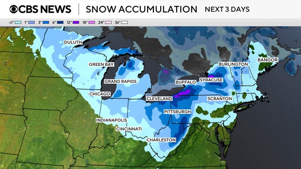
Map shows winter weather alerts and warnings
Millions remained under various winter weather alerts and warnings as the storm traveled eastward on Monday, including blizzard warnings in effect for sections of Michigan’s Upper Peninsula and ice storm warnings in place for parts of upstate New York and Vermont, according to the National Weather Service.
CBS News 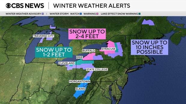
A flurry of winter storm warnings also remained active through Tuesday in many of those same areas, in addition to broader sections of the Midwest and Northeast, from Wisconsin up to Maine.
High wind alerts were issued for more than 114 million people across the eastern U.S. as the cold front moved in.


