

 Live Score – ESPN")


“Bomb cyclone” winter storm brings ice and snow, snarls thousands of flights. Maps show the latest forecast.

More than 3,000 flights were canceled or delayed across the United States on Sunday after a winter storm packing ice and snow slammed the Midwest and Great Lakes regions during the busy travel period between Christmas and New Year’s.
A system that was sweeping across the Great Lakes and Great Plains regions on Sunday went through rapid intensification and became a so-called “bomb cyclone,” or explosive cyclogenesis, which occurs when cold air and warm air collide. The clashing of arctic air and record-high temperatures in the south causes air pressure to drop sharply, leading to powerful winds, heavy rain or snow and dangerous weather like blizzards.
There were approximately 20 million Americans under wind alerts on Sunday morning — by the late afternoon, the number rose to more than 50 million.
On Saturday, another storm system dumped 4.3 inches of snow in New York City’s Central Park. It was less than what forecasts had predicted, but amounted to the first New York City snowfall greater than four inches since January of 2022, according to CBS News New York meteorologist Matthew DeLucia.
At least 4,400 flights have been canceled across the U.S. since Friday, and thousands more were delayed, according to the flight-tracking website FlightAware.
Thomas Hengge/Anadolu via Getty Images
The National Weather Service warned of hazardous travel conditions from the Great Lakes through the northern mid-Atlantic and southern New England, with the potential for tree damage and power outages. The storm had weakened by Sunday, but forecasters said a plunge of frigid arctic air moving southward into the Great Plains would bring more heavy snow, blizzards and widespread blustery conditions to huge swaths of the country.
Map shows winter storm warnings
On Sunday, More than 38.7 million people were under a winter weather advisory, while 9.6 million others were under a winter storm warning or winter storm watch. Another 2.7 million were under a blizzard warning.
The alerts came as arctic air surges into the Great Plains region, setting the stage for a rapidly intensifying winter storm, CBS Philadelphia meteorologist Andrew Kozak said. The snow was forecast to expand over the upper Midwest later in the day, ultimately leading to heavy snowfall accompanied by powerful winds in the evening.
CBS News 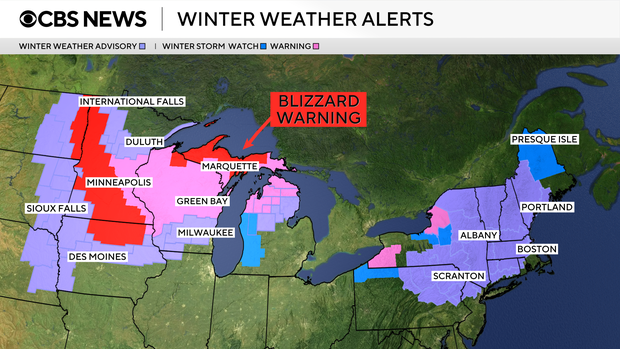
Winter storm advisories and warnings are in place through Monday in parts of Michigan, Minnesota, Wisconsin, and New York, where a forthcoming winter storm warning is set to take effect Monday in Buffalo and remain active through Friday morning, according to the National Weather Service.
Additional winter weather advisories are in place for parts of Massachusetts, including Boston and surrounding areas; upstate New York, including Albany; Illinois, Iowa and the Dakotas.
States stretching from Texas all the way up through Pennsylvania, New Jersey and Western New York could all see wind gusts over 60 mph. Several tornado warnings were issued in central Illinois on Sunday, with search and rescue operations underway in Mt. Zion, Illinois, after reported damage from a suspected tornado.
Map shows forecast for ice conditions
Ice is the biggest concern for areas across the Northeast, which are forecast to see a wave of freezing rain develop on Sunday ahead of the same weather system currently impacting the middle of the country. Icy conditions will likely spread through interior areas of New England by Sunday night, Kozak said, adding that the region is expected to receive a mix of snow, sleet and freezing rain overnight into Monday morning.
CBS News 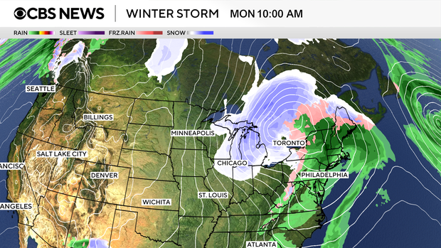
CBS Philadelphia urged local residents to be aware of potentially slick roads and sidewalks after the region saw a mix of snow, sleet and freezing rain. Temperatures are expected to be above freezing during the day on Sunday and continue to warm into Monday, but forecasters warned that the reprieve would be brief ahead of the approaching cold front that will likely linger through the end of the week.
More snow and cold in the forecast
Forecasters predict more snow is on its way for much of the northern part of the country.
Americans from the upper Midwest to the Great Lakes are bracing for blizzard conditions, which are expected to set in Sunday night and continue into Monday. In the upper Great Lakes, people could see more than a foot of snow — and, potentially, as much as two feet — accumulate, especially along the south shore of Lake Superior, according to Kozak. Near-whiteout conditions are also forecast in that area south of the lake.
CBS News 
In the Northeast, where snow wrapped up across central and southern New England on Saturday with 4 to 8 inches in some spots, colder-than-normal temperatures are expected for the rest of the weekend. But the National Weather Service noted that parts of the region would likely see a mix of snow, sleet and freezing rain by Monday.
In the interior parts of the Northeast, 6-10 inches of snow was expected through Monday in certain places.
After that, cool air moving in throughout the week behind the cold front will allow for lake effect snowfall to pile up, with 1-2 feet possible in some areas.
CBS News weather producer Elie Morrison and CBS News meteorologist Nikki Nolan contributed to this report.


